See the following flier for more information about local government cooperation with Enbridge and Enbridge’s WDNR Permit, including public meetings to attend. Full text of flier below.
To be an ally, our actions must align with our words. We stand with Bad River!
To be in solidarity with the Bad River Band as the Band continues to assert their sovereignty as a Tribal Nation
To honor the treaties by protecting the ecosystems which support the rights of Ojibwe poeple to hunt fish, and gather.
To defend the waters and lands from the harm caused by pipeline construction and the ongoing threat of an oil pipeline in the Great Lakes watershed.
To protect our communities from the sexual violence & trafficking perpetrated by pipeline workers in communities impacted by extractive industry.
Local Government Cooperation with Enbridge
City of Ashland selling water to Enbridge Enbridge has approached the City of Ashalnd Public Works Committee about selling water to Enbridge for the construction of the Line 5 reroute project. On Feb. 11, 2020 the City Council unanimously passed a Resolution “to support the efforts of the Bad River Band of Lake Superior Chippewa to remove the Enbridge Line 5 pipeline from the Bad River Watershed.” To be an ally, our actions must align with our words and selling water to Enbridge goes against the Bad River Bands efforts to remove the pipeline from the watershed. Public Works Committee Meetings: 5:30pm on 4/9, 5/14 City Council Meetings: 6pm on 3/31, 4/7, 4/21, 5/21, 5/26
Cooperative Agreements with Sherriff Departments Enbridge is trying to establish Cooperative Agreements with the Sherriff Departments in Ashland, Bayfield, and Iron Counties. Ashland and Iron County both passed agreements in February. There’s an effort in Ashland to have a re-vote. Bayfield County is considering a modified version after voting no in February. There is a conflict of interest with teh Sheriff Departments serving to protect the Bad River Band and then having a cooperative agreement with Enbridge. The priority needs to be serving and building trust within our local communities, not protecting a Canadian company. Ashland County Board Meetings: 9am on 3/24, 4/21 Bayfield County Board Meetings 6pm on 3/31, 4/28 Iron County Board Meetings: 6pm on 3/31, 4/28
Hearing about Enbridge’s WDNR Permit
The Bad River Band is continuing to object to the WDNR permiting of the LIne 5 reroute and the case is now being heard by Bayfield County’s Judge Anderson. There is no public comment oppertunity during these proceedings. Instead lawyers representing Bad River and lawyers from the WDNR and Enbridge will be presenting their cases to the Judge Anderson for a decision. Next hearing: 1pm, Thursday April 16th Location: Bayfield County Courthouse with live streaming to the Iron County Courthouse. No virtual option
Both the counties and the state of Wisconsin have weight limits on their roads during the spring thaw.
Ashland County: On March 2, 2026 the Ashland County Highway Department released un update detailing the trunk highway seasonal weight limitations. As you can see in the attached news release, starting March 5, weight is restricted to 4 tons per axle on Ashland County trunk highways. County trunk highways are distinct from state highways. This WIDOT map shows County trunk highways, differentiated from state highways.
Enbridge equiptment is subject to these restrictions as well. See additional details about the Ashland County seasonal road restrictions, including information about special hauling permits here.
State of Wisconsin: The WIDOT also weight limits for Seasonal Posted Roads and for Class II Roads. All restrictions began on Monday, March 9, 2026. (The reroute is all within Zone 1 (Ashland, Iron, and Bayfield Counties)).
Class II highways: The state restricts weight on all Class II roads. These are state highways that are judged to have unstable condition of the roadway subgrade during the period when frost is leaving the ground such that the travel of vehicles with overweight permits would cause undue damage to the roadway.
During this time, most divisible load multiple trip permits exceeding legal axle weights or 80,000 pounds (the legal load limit) are suspended, and overweight non-divisible multiple trip and single trip permits must stay off highway sections designated as Class II.
Springtime Posted Roads: The sate of WI also restricts some state numbered highways. These roadway sections are too weak to withstand even the legal load limit (80,000 pounds) during the seasonal freezing and thawing period.
These highway sections have signs posted indicating the allowable weight limits during the period normally from the second week in March till late April or early May.
Enbridge will likely use chainsaws to deforest the easements during this timeframe, and do other work they can do without bringing heavy machinery on the restricted roadways.
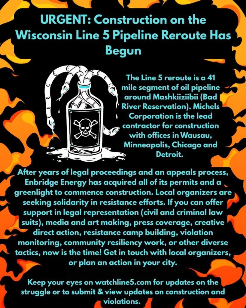
The Line 5 reroute is a 41 mile segment of oil pipeline around Mashkiiziibii (Bad River Reservation). Michels Corporation is the lead contractor for construction with offices in Wausau, Minneapolis, Chicago and Detroit.
After years of legal proceedings and an appeals process, Enbridge Energy has acquired all of its permits and a greenlight to commence construction. Local organizers are seeking solidarity in resistance efforts. If you can offer support in legal representation (civil and criminal lawsuits), media and art making, press coverage, creative direct action, resistance camp building, violation monitoring, community resiliency work, or other diverse tactics, now is the time! Get in touch with local organizers, or plan an action in your city.
Keep your eyes on watchline5.com for updates on the struggle or to submit & view updates on construction and violations.
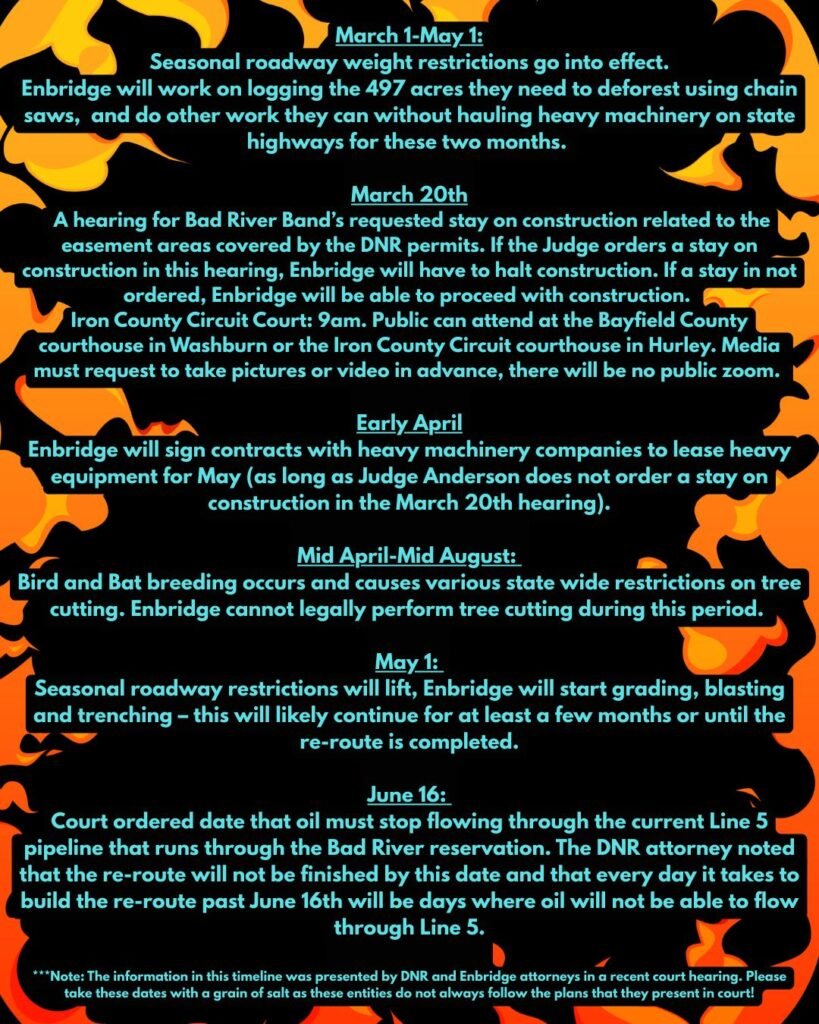
Line 5 Construction Reroute Timeline March 1-May 1 Seasonal roadway weight restrictions go into effect in Wisconsin –> Enbridge will work on logging the 497 acres that need to be deforested using chain saws and do any other work they can without bringing heavy machinery onto the state highways for these two months. See below for more information on the weight restriction regulations: https://wisconsindot.gov/Pages/dmv/com-drv-vehs/mtr-car-trkr/ssnl-wt-rsrctns/class2roads.aspx
March 20 @ 9 AM, legal hearing – Public can attend at the following locations: Washbourn Circuit Court – 117 E 5th St, Washburn, WI Iron County Circuit Court – 300 Taconite St # 101, Hurley, WI Hearing for Bad River Band’s requested stay on construction related to the easement areas covered by the DNR permits. If the Judge orders a stay on construction in this hearing, Enbridge will have to halt construction, if a stay is not ordered Enbridge will be able to proceed with construction. Media must request to take pictures or video in advance, there will be no public zoom option.
Early April: Enbridge will sign contracts with heavy machinery companies to lease heavy equipment for May (as long as judge Anderson does not order a stay on construction in the March 20th hearing).
Mid April-Mid August: Bird and bat breeding occurs and causes various state-wide restrictions on tree cutting. Enbridge cannot legally perform tree cutting during this period.
May 1: At this point the seasonal roadway restrictions will lift and Enbridge will start grading, blasting and trenching — this will likely continue for at least a few months or until the re-route is completed.
June 16: Court ordered date that oil must stop flowing through the current Line 5 pipeline running through the Bad River reservation. The DNR attorney noted that the re-route will not be finished by this date and that every day it takes to build the re-route past June 16th will be days, where oil will not be able to flow through Line 5.
***Note: The information in the timeline below was presented by DNR and Enbridge attorneys in a recent court hearing. Please take it with a grain of salt as these entities do not always follow the plans that they present in court!
On Tuesday, both the Bayfield County Board of Supervisors and the Ashland County Board of Supervisors is meeting and potentially voting on a cooperative agreement between the County Sherrifs Dept. and Enbridge where sherrifs would provide law enforcement services for Enbridge and Enbridge will reimburse them. Show up on Tuesday February 24th to voice your concerns.
Ashland County Board of Supervisors Meeting: Courthouse, 201 Main st. W, Ashland Tuesday, February 24th at 9am
Bayfield County Board of Supervisors Meeting Courthouse, 117 E 5th St., Washburn Tuesday February 24th at 6pm
Services will include:
Assign officers to perform patrols of the Project site and surrounding locations on a daily basis to promote safety and wellbeing on the Project site.
Maintain the peace in and around the Project site, including assistance with crowd control measures.
Provide any required emergency or environmental services consistent with statutory duties.
Coordinate with Enbridge Project personnel as required to perform statutory duties.
Provide transportation, parking, and traffic control services.
Respond to calls for service received through general dispatch for incidents at the project site.
Respond to accidents or incidents at the Project site requiring first responder services, including but not limited to administration of first aid and completing accident reports.
Assist in the development and presentation of education-based programs to address public safety concerns regarding the Project.
Of exceptional concern in the agreement is Section G. which appears to highlight keeping all financial records hidden and it tip toes on all files being hidden. I.e. no FOIA allowable. This is an extra caveot to what they did for the Line 3 agreement. Likely because people were able to FOIA the financial records and then publicize them.
Of additional concern, is that it is likely that the County Board agenda does not comply with the notice requirements of the open meetings law. See pp 14 to 17 of this compliance guide. The law says that the agenda needs to appraise the public of what will be discussed and that if the government body can anticipate a lot of public interest then they need to be more specific. If that agreement relates to Enbridge then the agenda title should say that explicitly since the public is surely interested in an agreement that relates to Enbridge. https://www.wisdoj.gov/Open%20Government/OML_guide.pdf
On February 13th, an administrative law judge upheld a key permit granted last year by Wisconsin’s Department of Natural Resources (DNR) for Enbridge to build the line 5 reroute (41 miles of new pipeline) through the watershed of the Bad River Band of Lake Superior Chippewa in northern Wisconsin. This decision comes after the six-week contested case hearing last fall in which attorneys and expert witnesses presented evidence showing that the DNR permitted the project without fully understanding the risks.
Bad River Band has filed a petition for judicial review to challenge Administrative Law Judge Angela Chaput Foy’s decision. In their petition, they request an immediate stay to halt any construction until the Court can hear the legal claims.